Less dividing, more paper and no rocks!
by John Curnow on 21 Nov 2016
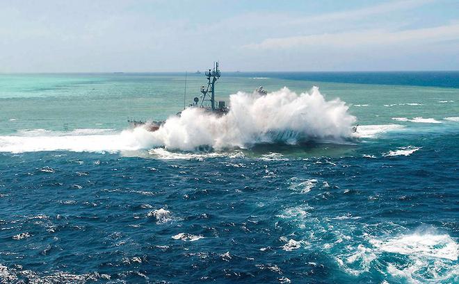
USS Guardian standing up to the mighty sea - for a while anyway... US Navy
Well it was written more than a year ago now. Yet just like plots on the proverbial paper chart, ever since Paper. Ruler. Dividers was published there have been some marks notated on the course, as it were. So thank you everyone for reading, enjoying, the great discussion that has ensued, and especially your comments about how it was about time that this subject matter was no longer the elephant in the room.
Now it is true that some also missed the overall thrust, and did not review the example of the time, which was the VO65 known as Team Vestas Wind. Subsequent to that, in a later piece we also highlighted how the mighty US Navy was going back to teaching celestial navigation at Annapolis after a 20-year hiatus.
So please pay attention now, because also in the intervening time, much more has come to light about the USS Guardian, an Avenger-class mine countermeasures ship (MCM–5). She ran herself up on the Tubbataha Reefs in the Philippine Islands. OK. ‘She’ had nothing to do with that. Rather, the officer in charge told the navigator to trust the electronics because they were newer and updated. By the way, please note that he, and everyone in the ship’s crew above him were relieved of duty.
Here’s the thing in a nutshell. The ship’s electronic charts misplaced the reef by an incredible eight nautical miles.
Remember, that’s the horizon at sea level!!! Yet on the ship’s back-up paper charts, evidence of this clear and distinct barrier was absolutely crystal. Just take another look at the pics now…
What was the result? One wreck that had to be cut up and then hauled away. OK, she was laid down in 1985, but as a minesweeper, she no doubt still had years of service left in her. Also, the US Government also had to dip into the coffers and pay damages to their Filipino counterpart.
So what do we learn? Well firstly, this is not like driving a car, or for that matter flying commercial aircraft. With cars, the roads are set in concrete and bitumen. Yes they build new ones, and there are trees and bridges overhead, but things don’t come up from the bottom that often to ruin your day. Sinkholes are not that common and bomb craters mean you should possibly look at moving and drive something more suitable, such as a tank!
Before we digress too far, your car can still put you in a place you are clearly not, but street signs, kerbs, traffic lights and all will keep you organised in the main. At sea, GPS and digital navigation can be accurate, assuming the fixes from the satellites are accurate, and the end user is using the Latitude and Longitude generated to pinpoint their position on a paper chart.
One notes here the ‘toaster’ example from 1991. Satellite Navigation in those days used one, and at best two satellites to give you a fix. If they were oblique, which was very often, the data supplied could only really be used as a test for your DR skills or make you do better sightings of any landmarks nearby.
Equally, one of the main points from the first article is who generated your charts in the first place? If it was not the Hydrographer, then taken with a grain of salt is about all they are good for. Also, updates can be over two months behind and then there is blind faith. One experienced navigator put a new chip into his approved system, and then promptly put the boat on the bricks, which were a full two nm away from where the chartplotter said they should be. No one was injured, thankfully, but the point is this was meant to be the best and most up to date, yet just like our USN friends, he paid the ultimate price.
Some respondents to the original piece are probably saying many things by now, and shaking their heads too, but to them we merely say, please read the chart suppliers’ disclaimers. They do release the manufacturer from any liability surrounding the accuracy of the positions generated. Importantly, these days now that at least six sats generate your position, all manufacturers will have you within a fender’s diameter of each other. The scary part is just where all the bricks and lumpy bits have gone. They can scatter on the digital chart just like a bunch of cats.
So we come back to education. Many boaters go to sea with only digital navigation. The next part is that many do so with little knowledge or understanding of how to fully operate their plotters properly. This includes the correct magnification to ensure that they don’t hit known obstacles. Once again we cite Team Vestas Wind who freely admitted that was their error on the Cargados Carajos Shoals in the Indian Ocean.
So the soothsayers are now claiming we have just the one example. Well another mariner came out of a Queensland harbour, put the boat on auto-pilot to match his plot on the digi chart. Alas, he cut a corner where a finger of the reef came out, and tore the bottom off the boat. By zooming in he would have avoided the embarrassing call to the insurer.
So yes, paper should not just be around in the event of loss of power. If you have no depth sounder as well, a series of plots will also let you see about tide and improve your DR exponentially. Nothing can replace the Notices to Mariners and paper updates, so it is not just for when you are going somewhere new, prudence demands you have it for where you are now. Should you become incapacitated, who will call the authorities and tell them where you are?
Now before someone says, Luddite, this is not an anti-digital piece. It is merely about correct and proper use, and the complete removal of blind faith by saying there are limitations, so know them! Digital is not always accurate and there are misgivings with the technology, such as source and updates, your use of it, correct magnification, as well as the reliability of the sats themselves, your power on board, and any cartography mistakes inherent in the source files. Please check the notes on the top of a paper chart, for they are the gold you must pan for.
Now a piece this short cannot cover off everything, but we do ask that you consider additional education, putting your head out the companionway, Pilot Guides, NTMs, books and if you are insured with someone like Pantaenius Sail and Motor Yacht Insurance, then ask a lot of questions, because years of nautical miles, a deep pool of knowledge and an impressive set of contacts count for a lot.
Cover with the crew that know boats, is both sensible and prudent. Hopefully we have shown that being less divisive, using more paper and not hitting the bricks is more than worthwhile. In the end, please go to www.pantaenius.com.au or call +61 2 9936 1670 today and see why everything from superyachts to global cruisers choose the marine originated, all-risk policy that only Pantaenius can provide you with.
If you want to link to this article then please use this URL: www.nzboating-world.com/149828