Please select your home edition
Edition
PredictWind - GPS 728x90 TOP


Extreme Weather Warnings - Don't get caught out!

by PredictWind 23 Sep 2022 16:05 NZST
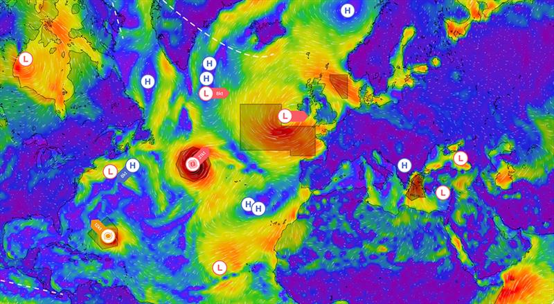
GMDSS Map © PredictWind

When doing a quick check on the weather forecast, it is easy to miss the indicators which can often signal extreme weather, even when the averaged forecasted conditions are benign. To ensure you do not miss these extreme weather events, we now have alerts on the forecast pages and a new GMDSS weather warning overlay on the forecast maps.

PredictWind now uses the following key indicators to alert customers of extreme weather events:

  • Lightning Index
  • Cape Index for Thunderstorms
  • Rain Squalls
  • High Gusts
  • Fog
  • Wind Chill
  • Wind against current
  • Tropical Cyclones
Users are able to see these warnings throughout the PredictWind ecosystem.

Forecast Tables:

The potential for extreme weather is shown in a new row called "Warning". If an event is predicted, it is shown with a warning symbol.

Daily Briefing:

We now have a new field called Extreme Weather, and the relevant warning is displayed when these conditions are forecast.

Forecast Maps & GMDSS weather warnings:

You can now view the GMDSS (Global Maritime Distress and Safety System) weather warnings overlaid on any of our weather maps. The text forecasts are analysed in the PredictWind cloud using machine learning. Then each weather system, front and warning region is plotted accurately on the map, giving you a world-first, global view of the GMDSS forecast.

Weather Routing:

In the weather routing tables, you will see the extreme events marked with a warning symbol. In addition, on the weather routing map, you will also see the extreme events highlighted in orange, ensuring you are alerted to possible extreme weather events. The GMDSS overlay can also be displayed on the weather routing pages.

The extreme weather feature, exclusive to PredictWind, has been created to give maximum safety on the water.

Related Articles

PredictWind: Perfect complement to your Starlink
Aiming to reshape the way mariners use their communications devices We at PredictWind are thrilled to announce our latest initiative that aims to reshape the way mariners use their communications devices. Posted on 18 Sep
More features with the DataHub 2.0 by PredictWind
Showcasing its commitment to providing mariners with more PredictWind, the world leader in marine forecasting, introduces the updated DataHub, showcasing its commitment to providing mariners with more. More features, more connectivity, increased safety. Posted on 1 Sep
PredictWind introduces revolutionary AI Polars
Engineered to optimise routing based on your boat's real-time data PredictWind, the world leader in marine forecasting, has unveiled a groundbreaking innovation that will redefine the future of weather routing with Automated AI Polars. Posted on 19 Aug
Comparing Starlink and Iridium GO! Exec
Exploring the advantages and drawbacks of both systems for reliable weather data When it comes to sailing, obtaining accurate weather information is vital for ensuring safety and comfort on the open seas. Posted on 23 Jul
New models boost Weather Routing accuracy
Three additions added to list of high-resolution Weather Routing models PredictWind has a mission to provide the most accurate weather data on Earth. We are excited to announce three additions to our list of high-resolution Weather Routing models. Posted on 26 Jun
Free Atlantic crossing webinars - Part two
Digging deeper into how to use the equipment you will need out on the water Last week we kicked off two part webinar series covering everything you need to know for a successful Atlantic crossing. Posted on 17 Oct 2022
The “Game Changer” for Weather Routing
Automatic Wave Routing PredictWind's newest feature - Automatic Wave Routing allows users to see highly detailed wave data and how their vessel will perform in all wave conditions, along their route. Posted on 19 Aug 2022
AIS Vessel Positions data on PredictWind
PredictWind has developed is the ability to download AIS data via satellite connection AIS is a system where boats that have an AIS transponder installed can automatically broadcast their vessel identity, real-time position, course, and speed, using VHF frequencies. Posted on 27 Jun 2022
PredictWind departure planning
With advanced weather technology, there is no reason to get caught out in unfavorable weather With advanced weather technology, there is no reason to get caught out in unfavorable weather conditions. PredictWind introduced the first online Departure Planning tool over a decade ago and now with new updates Posted on 30 May 2022
PredictWind - Routing 728x90 BOTTOMPredictWind - GPS 728x90 BOTTOMPredictWind - Offshore App 728x90 BOTTOM